Press Release: NASA’s Curiosity Rover Completes Two-Day Drive Using Navigation Software Developed at Carnegie Mellon
Multi-Day Autonomous Driving Enables Rover To Cover Ground Faster
Contact: Byron Spice / 412-268-9068 / bspice@cs.cmu.edu
 PITTSBURGH—Using autonomous navigation software first developed at Carnegie Mellon University’s Robotics Institute, NASA’s Mars rover Curiosity this week completed its first two-day autonomous drive, a new technique that enables the mobile laboratory to cover ground faster.
Since July, Curiosity has been on a 5.3-mile trek from where it worked for the first half of 2013 to the lower reaches of Mount Sharp, a 3.4-mile-high peak within the Gale Crater that is the rover’s next major science destination. Autonomous navigation software can quicken the pace by allowing the rover to safely drive itself across terrain not previously evaluated by human rover drivers on Earth.
Mark Maimone, a rover driver at NASA’s Jet Propulsion Laboratory (JPL), said the two-day drive completed Monday was significant because it was the first time the rover had completed one day’s drive and then resumed autonomously from the same point the next day.
“Autonomous navigation already has made it possible for the rover to extend its range each day, continuing to operate beyond the area we have been able to evaluate in advance,” said Maimone, who earned his Ph.D. in computer science at CMU and worked as a post-doctoral fellow at the Robotics Institute before joining JPL. “But what really matters is how far we can drive between planning cycles. Autonomous drives over multiple days will allow Curiosity to keep moving, even on weekends and holidays when staff members aren’t available.”
The high-level planning performed by the autonomous navigation software is based on a program called Field D*, which was created by Tony Stentz, director of CMU’s National Robotics Engineering Center, and his former student, Dave Ferguson, under sponsorship of the Army Research Laboratory. The software builds a large-scale map of the terrain a robot encounters, helping it not only evaluate paths forward, but providing a memory so that it can retrace its steps or plot a new path if it encounters a cul-de-sac or some other obstacle.
Field D* is one of a progression of programs that began in the early 1990s that were used on a number of autonomous vehicles at Carnegie Mellon, including NavLab 2, a self-driving off-road Humvee, and Crusher, an experimental unmanned ground combat vehicle. Researchers at Carnegie Mellon and JPL subsequently adapted the software for use on planetary rovers, which have computers with less processing power than those typically available on Earth.
 The software was uploaded to the Mars Exploration rovers in 2006 and the rover Opportunity first used the autonomous capability in 2007. But high-level planning was used only sparingly by Opportunity and its twin, Spirit.
“Now that the science team has decided to hightail it to Mount Sharp, we have to look for ways to cover more distance,” Maimone said, “so Curiosity is now making greater use of autonomous navigation. Curiosity has already added nearly 500 meters to her odometer using autonomous navigation.”
Maimone said humans plan the first part of each drive based on high-resolution imagery from the rover. Once the rover has completed the human-directed portion of the drive, autonomous navigation kicks in, enabling the robot to analyze the images it has taken during the drive to calculate a safe driving path.
In the two-day drive that began Sunday, Curiosity followed a 180-foot route that rover drivers at JPL had evaluated and concluded was safe. The autonomous-driving portion began where that left off, with Curiosity evaluating the best way to each designated waypoint ahead, covering another 125 feet that day.
At the end of the day, Curiosity went into energy-conserving sleep mode overnight, but not before storing some key variables, such as the direction it was driving when it stopped and whether it had classified the next 10 feet in that direction as safe. On Monday, it resumed operations, evaluating the terrain ahead for safe driving and completing another 105 feet.
“We’re pleased to know that Field D* has become part of NASA's flight software and is helping Curiosity achieve its scientific goals,” said Stentz, who noted that Carnegie Mellon is no longer actively involved in the program.
JPL, a division of the California Institute of Technology in Pasadena, manages the Mars Science Laboratory Project for NASA's Science Mission Directorate, Washington, and previously managed the Mars Exploration Rover Mission. JPL designed and built the Curiosity rover. For more information on the Mars Science Laboratory Project, see http://mars.nasa.gov/msl/.
###
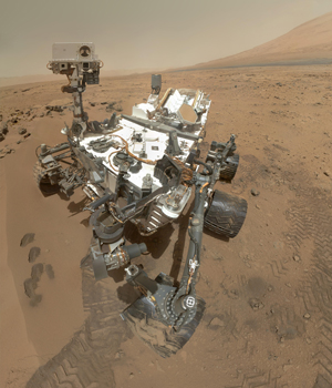
Curiosity (top photo) is using autonomous navigation software, first developed at Carnegie Mellon's National Robotics Engineering Center, to quicken its pace by allowing it to safely drive itself across terrain not previously evaluated by human rover drivers on Earth.
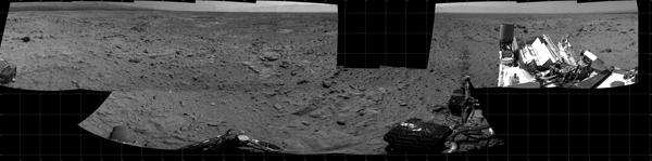
The photo above is a mosaic assembled from images taken during Curiosity's two-day autonomous drive.