
Exploring Earth
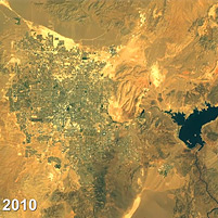
Time lapse view of Las Vegas
Watch deforestation unfold in the Amazon, water levels rise and fall in the Aral Sea or even desert urbanization as Las Vegas expands.
A new capability within Google Earth Engine lets users not only zoom in or out on any spot on the globe — but also move back and forth in time.
Researchers at Carnegie Mellon University's Robotics Institute, working with colleagues at Google and the U.S. Geological Survey (USGS), have adapted their technology for interactively exploring time-lapse imagery to create a tool that enables anyone to easily access 13 years of NASA Landsat images of the Earth's surface.
This new capability within Google Earth Engine enhances the public's ability to view the massive amount of imagery collected by the Landsat program between 1999 and 2011.
For the past 40 years, the Landsat program has continuously collected imagery of the Earth's surface and, since 2008, the USGS has made that imagery available free to the public.
But accessing that data — measured in petabytes, or quadrillions of bytes — has long been cumbersome, said Randy Sargent, a CMU system scientist in the Robotics Institute's CREATE Lab in Pittsburgh and a visiting researcher at Google.
"Google has improved access by building the largest library of Landsat imagery on hard-drive storage," Sargent said. "Google Earth Engine has already amassed more than 1.5 million Landsat images of Earth and this is growing by thousands of images per day as new satellite data is collected."
The new tool for Google Earth Engine, based on CMU's GigaPan Time Machine technology, takes this access to another level.
When combined with Google Earth Engine's massively parallel computation power, the Landsat image archive is transformed into a set of seamless, zoomable videos easily accessible from a modern web browser.
"The sheer volume of visual data is daunting to explore by conventional means," said Rebecca Moore, engineering manager of Google Earth Engine. "Together we can now offer an intuitive, effortless method to explore the planet in space and time."
Google, NASA and CMU previously collaborated to create GigaPan, a technology for capturing a mosaic of hundreds or thousands of digital pictures and stitching those frames into panoramas that be interactively explored via computer.
Related Links: Read full release | Google Earth Engine | GigaPan.org | GigaPan Time Machine | Robotics Institute