
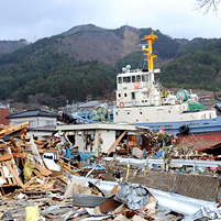
Japan Relief Efforts
U.S. Navy photo by Petty Officer 1st Class Matthew M. Bradley
In a disaster of apocalyptic proportions, experts at Carnegie Mellon University are assisting various agencies and first responders.
From data mining to mapping and translation, their efforts are meeting urgent needs in the aftermath of the Japan earthquake and resulting tsunamis.
"The amount of data flowing over social media during this crisis has been overwhelming. Within an hour after the 9.0 magnitude earthquake in Japan, 1200 tweets per minute were generated from Tokyo," said CMU's Jeannie Stamberger.
Stamberger is associate director of the university's Disaster Management Initiative (DMI). The DMI is based at CMU's Silicon Valley campus in Mountain View, California.
CMU's Ian Lane, an assistant research professor in Silicon Valley who is also fluent in Japanese, has expertise that was of immediate assistance.
"With the help of volunteers, within a few hours we had developed an architecture for the live monitoring of Twitter as well as a basic system to automatically identify the most critical tweets from the huge volume that were being generated," he said.
The CMU group then built a basic "Twitter parsing" system for the Japanese language.
For each tweet, it attempted to extract basic information — such as location and a person's name — when present within a tweet in which the user stated they were "safe and well."
Over the weekend this data was verified and entered into Google Person Finder, enabling people outside of Japan to verify that their friends and family are OK.
"Our framework bridges the gap between unstructured social media and structured data," Lane explained.
"Just by tweeting a message stating that they are fine and well, this information will become available to all their friends and family around the world via Google Person Finder."
Other efforts underway include CrisisCampSiliconValley, where volunteers, students and faculty arrived to develop country profiles and compile data streams for the United Nations Office for the Coordination of Humanitarian Affairs (UN OCHA).
Trey Smith, a CMU systems scientist and member of the Intelligent Robotics Group at NASA Ames Research Center, was able to work with Urban Search and Rescue (USAR) teams to get accurate maps from Google physically into the hands of USAR-deployed teams.
It enabled the USAR-deployed teams to better assist those on the ground in the rescue efforts.
"There is an urgent need for Japanese/English speakers to identify online local maps of areas in Japan by NetHope, an NGO deploying to the area," said Stamberger, noting CrisisCommons is the coordination group for that effort.
Stamberger has also created a Google MyMap of firsthand footage or reports of impact on the California coast.
Related Links: Silicon Valley Disaster Management Initiative | Carnegie Mellon Silicon Valley | Google Crisis Response